
 Continue with onX Maps
 Continue with Facebook


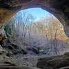
 Particularly Special Place


 Intermediate
Intermediate
Intermediate
 Intermediate
Land Manager: Hoosier National Forest - National Forest Service
 German Ridge: North Loop Hike
4.7 mi 7.5 km • 598' Up 182.16 m Up • 598' Down 182.14 m Down
 German Ridge: Southern Half Hike
11.9 mi 19.2 km • 1,497' Up 456.22 m Up • 1,495' Down 455.72 m Down
 Tipsaw Lake Trail
5.6 mi 9.1 km • 158' Up 48.21 m Up • 158' Down 48.18 m Down
Two Lakes Trail
13.1 mi 21.1 km • 1,389' Up 423.25 m Up • 1,393' Down 424.62 m Down
Jeffreys Cliffs - Lower Upper Trails
5.5 mi 8.8 km • 666' Up 202.86 m Up • 666' Down 202.89 m Down
 Jeffreys Cliffs Lower Trails
1.8 mi 2.9 km • 269' Up 81.88 m Up • 265' Down 80.81 m Down
Hawesville, KY


0 Comments