
 Continue with onX Maps
 Continue with Facebook


 Particularly Special Place


 Intermediate
Intermediate
Intermediate
 Intermediate
Land Manager: AZ State Land Department
 Honeybee Canyon Short Loop
12.3 mi 19.9 km • 456' Up 139.11 m Up • 457' Down 139.31 m Down

 Catalina, AZ
 Mount Kimball Out-and-Back
8.7 mi 14.0 km • 4,125' Up 1257.22 m Up • 4,124' Down 1256.97 m Down
Catalin…, AZ
Safford Peak
3.4 mi 5.5 km • 1,490' Up 454.08 m Up • 1,489' Down 453.96 m Down
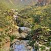
 Bear Canyon Loop
16.9 mi 27.2 km • 2,465' Up 751.48 m Up • 2,456' Down 748.6 m Down
Catalin…, AZ
Aravaipa Creek
11.0 mi 17.7 km • 585' Up 178.42 m Up • 197' Down 60 m Down
Mammoth, AZ
Babat Duag Out-and-Back
4.6 mi 7.4 km • 1,180' Up 359.74 m Up • 1,180' Down 359.55 m Down
Tanque…, AZ


0 Comments