
 Continue with onX Maps
 Continue with Facebook


 Particularly Special Place


 Easy
Easy

 Easy
Easy
 Valnontey Valley Tour
14.7 mi 23.7 km • 5,695' Up 1735.87 m Up • 5,702' Down 1738.03 m Down
Cogne, IT
 UTMB - Ultra - Trail du Mont Blanc
104.4 mi 168.0 km • 30,052' Up 9159.76 m Up • 30,053' Down 9160.09 m Down
Chamoni…, FR
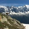
 Index Chairlift to Lac Blanc to Flégère Gondola
6.3 mi 10.2 km • 1,202' Up 366.45 m Up • 2,907' Down 886.09 m Down
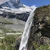
Boucle Vallorcine - Vallon de Berard - Refuge de la Loriaz
8.5 mi 13.6 km • 2,772' Up 844.97 m Up • 2,762' Down 841.95 m Down
Chamoni…, FR
Zermatt Lollipop
3.6 mi 5.8 km • 859' Up 261.88 m Up • 858' Down 261.64 m Down
Zermatt - Trift - Zmutt Village Loop
13.7 mi 22.1 km • 4,666' Up 1422.07 m Up • 4,663' Down 1421.13 m Down
Zermatt, CH


0 Comments