
 Continue with onX Maps
 Sign in with Facebook


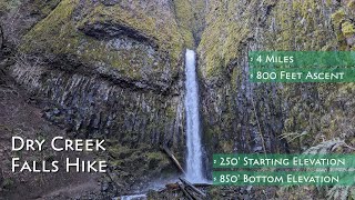
 Particularly Special Place


 Intermediate


 Intermediate
Land Manager: USFS - Mt. Hood National Forest - Zigzag Ranger Distict
 PCT: Herman Creek to Eagle Benson
18.1 mi 29.1 km • 4,399' Up 1340.93 m Up • 4,399' Down 1340.8 m Down
Cascade…, OR
 Wyeth State Park to North Lake
11.7 mi 18.8 km • 4,117' Up 1255.01 m Up • 4,118' Down 1255.3 m Down
 Beacon Rock Summit Trail
0.8 mi 1.3 km • 555' Up 169.25 m Up • 550' Down 167.63 m Down
Stevenson, WA
Dog Mountain Trail #147
6.5 mi 10.4 km • 2,802' Up 853.98 m Up • 2,801' Down 853.86 m Down
Carson, WA
 Multnomah Falls Loop
4.8 mi 7.7 km • 1,554' Up 473.69 m Up • 1,510' Down 460.14 m Down
Bridal…, OR
Falls Creek Falls Loop
5.9 mi 9.6 km • 1,425' Up 434.28 m Up • 1,424' Down 434.01 m Down
Stevenson, WA


0 Comments