Dogs Leashed

Features
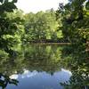
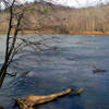
River/Creek · Waterfall
Overview
Explore through the forest and catch views of the dam spill waterfall constructed to power two mills from the late 1800's.
This trail has a good balance of reasonably challenging grades and some technical footing between more level stretches that let you just "enjoy the ride." Bring a small picnic in your pack to eat near the dam spill if you want to make a day of it.
Need to Know
Bring $3 exact change cash for the parking fee station.
The trailhead parking can be easy to miss; If you are coming up from the south on Roswell Road, take a right onto Riverside Rd right after you cross over the Chattahoochee River. You'll cross over another smaller bridge (over Big Creek) right away, and the trailhead parking access is to the left immediately at the other side of that bridge.
There are no bathrooms at the trailhead parking lot itself, but there are public restrooms at Riverside Park if you want to make a stop before your outing. It's about one block past the trail parking off of Riverside Rd.
Runner Notes
Watch your feet for lots of roots and rocks on some stretches of this trail as you enjoy the view.
Description
Begin at VC 1 from the parking lot along Riverside Road and take a hard right at VC 2. The trail switchbacks up to the top of an elevation ridge and then levels out where you can enjoy views across the hills through the trees. As the trail gently starts to rollercoaster through the woods, take a right at VC 4, a left at VC 6, then a right at VC 7. Keep straight/right at VC 20.
Upon reaching VC 21, take a left, possibly catching a glimpse of Oxbo Rd on the other side of Vickery/Big Creek before making a left at VC 23. (If you make a right at VC 23, you'll stay closer to the Creek on a parallel section of trail, but the view across the Creek also includes the road and several buildings. The section through the forest just to the south is also quite scenic and feels a bit more “away from it all”.) The elevation changes get more pronounced here and you'll have to watch your feet more as the terrain gets more technical.
Take a right at VC 24 and find VC 26 shortly after that at the end of a footbridge that crosses the Creek. The trail continues to the left of the footbridge next to a small cement barrier and plunges down sharply to meet up with the creek bed and runs parallel right next to it for a while. It narrows here and becomes a bit more 'rooty' as it continues following the river to climb back up to VC 27. Make a left at VC 27 and enjoy views from higher up again as you move along an elevated ridge above the creek. Keep right at VC 25 and head straight through VC 18 and 17.
At VC 16, take a hard right for the spur towards Vickery Creek Falls/Big Creek spillway dam (to VC 19). Although it can be a bit crowded (especially on weekends), the area right next to the dam falls offers shady and scenic views in a generous clearing with areas to sit and rest on the rocks and a park bench along the trail. Head back up to VC 16 and stay straight. The next intersection will be VC 11, although the trail map sign will actually be up the trail to the left a little ways. Take a right here; however, towards VC 15 is one of the most scenic areas of the run. This will take you down to a large wooden covered footbridge, which offers some lovely views of the creek rapids on either side. On the other side is
Roswell Mill Ruins in historic Old Mill Park. In addition to a history fix, the area offers water fountains and a 'real bathroom' (the second brick building once you get across the bridge). Head back across the bridge to continue the run.
When you get back to VC 11, make a left and continue heading east (straight) through VC 10. Make a right at VC 9 and keep straight at VC 8, taking you south towards VC 4. Make a right at VC 4 and continue back along the initial section heading south to VC 2 and VC 1 to the parking lot.
History & Background
The dam spill once served two mills (of the Roswell Manufacturing Co.), the main buildings of which still stand at the other side of the covered footbridge. Constructed in 1839 and 1853 respectively, they were burned by Union Forces in 1864. The newer of the two was rebuilt after the war and destroyed by a fire again in 1926, after which it was abandoned.
The buildings from the 1839 mill are just on the other side of the covered footbridge.
Contacts
Shared By:
Heather Pruner
with improvements
by Karen Tittle

 Continue with onX Maps
 Continue with Facebook


 Particularly Special Place


 Intermediate

 Allenbrook Trail


 Columns Drive to Sope Creek Figure 8
 Chochran Shoals Chattahoochee River
 Kennesaw Mountain Short Loop


 All Clear


0 Comments