
 Continue with onX Maps
 Continue with Facebook


 Particularly Special Place


 Difficult
Difficult
Difficult
 Difficult
Land Manager: Arizona Trail Association
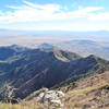
 Miller Peak from Montezuma's Pass
9.9 mi 15.9 km • 2,910' Up 886.97 m Up • 2,910' Down 886.92 m Down
 Sierra…, AZ
Carr Peak via Miller Canyon Trail
Sierra…, AZ
Carr Peak via Miller Canyon Trail
10.3 mi 16.5 km • 3,488' Up 1063.26 m Up • 3,488' Down 1063.16 m Down
 Sierra…, AZ
 Clark Spring Trail #124 Out-and-Back
3.7 mi 5.9 km • 505' Up 153.91 m Up • 505' Down 153.81 m Down
Old Pueblo 50 Course
26.3 mi 42.3 km • 3,295' Up 1004.44 m Up • 3,307' Down 1008.05 m Down
Corona…, AZ
Josephine Saddle via Super Trail
6.2 mi 9.9 km • 1,652' Up 503.48 m Up • 1,620' Down 493.91 m Down
Arivaca…, AZ
 Florida Canyon Trail #145
8.8 mi 14.1 km • 3,466' Up 1056.56 m Up • 3,466' Down 1056.36 m Down


0 Comments