Trail Run Project Logo

Easy at first followed by a wet spaniel scramble to the NW plateau.


Your Rating: Rating Rating Rating Rating Rating      Clear Rating
Your Difficulty:
Your Favorites: Add To-Do · Your List
Zoom in to see details
Map Key

8.1

Miles

13.1

KM

83%

Runnable

4,650' 1,417 m

High

1,337' 408 m

Low

3,433' 1,046 m

Up

484' 147 m

Down

9%

Avg Grade (5°)

92%

Max Grade (43°)

Dogs Unknown

Description

The first few miles of this trail are a gradual climb that is very doable. As you get to the ponds, it gets a bit more tricky but the views open up of the most remote basin in Baxter. The boulders get bigger as do the holes between them. Part of the trail follows a steep stream on bedrock for a bit. A quick side trip to Davis pond is worth it.

Up from Davis pond, it is very wet, steep and mossy. Turn off the Russell Pond Trail at 6.4 miles (10.3k) and take it until you get to the Saddle Trail at about 13.3 miles (21.4k) above treeline. Once up on the ridge, the views are great.

Shared By:

Bryan Gagner

Trail Ratings

  4.5 from 2 votes

#1

in Russell Pond

#9097

Overall
  4.5 from 2 votes
5 Star
50%
4 Star
50%
3 Star
0%
2 Star
0%
1 Star
0%
Trail Rankings

#1

in Russell Pond

#123

in Maine

#9,097

Overall
7 Views Last Month
1,122 Since Mar 27, 2015
Difficult Difficult

0%
0%
0%
0%
100%
0%

Photos

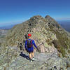
The Northwest Basin Trail
Mar 27, 2015 near Patten, ME
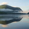
Overlooking the Northwest Basin
Mar 27, 2015 near Patten, ME

0 Comments

Weather


Current Trail Conditions

Unknown
Add Your Check-In

Check-Ins

none
Welcome

Join the Community! It's FREE

Already have an account? Login to close this notice.