
 Continue with onX Maps
 Continue with Facebook


 Particularly Special Place


 Difficult
Difficult
Difficult
 Difficult
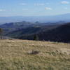
 Los Alamos County Low Point to High Point
38.0 mi 61.1 km • 9,338' Up 2846.1 m Up • 7,914' Down 2412.07 m Down

 Falls Trail
2.9 mi 4.6 km • 360' Up 109.82 m Up • 360' Down 109.85 m Down
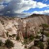
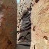
 Slot Canyon Trail Out and Back
3.0 mi 4.8 km • 815' Up 248.3 m Up • 814' Down 248.14 m Down
 Santo D…, NM
 Soda Springs Loop
9.9 mi 16.0 km • 1,343' Up 409.37 m Up • 1,348' Down 410.77 m Down
Goblin Colony Hike
3.9 mi 6.3 km • 587' Up 179 m Up • 585' Down 178.37 m Down
Jemez P…, NM
Arroyo Hondo
2.8 mi 4.6 km • 435' Up 132.48 m Up • 434' Down 132.15 m Down


0 Comments