
 Continue with onX Maps
 Continue with Facebook


 Particularly Special Place


 Intermediate
Intermediate
Intermediate
 Intermediate
Land Manager: USFS - Fremont & Winema National Forest Office
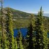
 Blue Lake Basin Loop
13.5 mi 21.8 km • 1,365' Up 416.11 m Up • 1,370' Down 417.48 m Down

 Aspen Butte
13.3 mi 21.4 km • 2,638' Up 803.98 m Up • 2,638' Down 803.95 m Down
 Klamath…, OR
 Mountain Lakes Loop
15.5 mi 25.0 km • 2,901' Up 884.26 m Up • 2,901' Down 884.19 m Down
Klamath…, OR
Devils Peak Loop Hike
14.0 mi 22.5 km • 2,984' Up 909.45 m Up • 2,985' Down 909.68 m Down
Prospect, OR
Boccard Point
10.1 mi 16.2 km • 1,489' Up 453.93 m Up • 1,487' Down 453.15 m Down
Ashland, OR
Viewpoint Mike Trail
5.0 mi 8.0 km • 1,008' Up 307.32 m Up • 1,008' Down 307.26 m Down


0 Comments