Dogs Leashed

Features
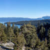
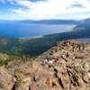
Commonly Backpacked · Fishing · Lake · River/Creek · Swimming · Views · Waterfall · Wildflowers · Wildlife

This trail will most likely be snowed out in winter. Mid-to-late summer is the perfect time to go.
Overview
A backpacking route taking you into the Desolation Wilderness of Tahoe National Forest, allowing you to access beautiful mountain lakes. Flexibility to extend and shorten your adventure using surrounding trails.
Need to Know
Parking is free at the
Rockbound Trail (16E08) just west of Wrights Lake. They have a sign-in station at the trailhead for day running, but overnight running requires a permit for the Desolation Wilderness. You can obtain the permit here:
recreation.gov/permits/233261. When selecting your permit, Leland Lakes is in Zone 10. Bring bear spray and a bear canister for overnight camping food.
Description
The trail begins at the
Rockbound Trail (16E08) at the parking lot just west of Wrights Lake. Follow the Rockbound trail up and over the pass until you come to a fork in the trail at 6 miles, just past Lake Doris. Take the Schmidell trail to the left until you reach the southeast end of Lake Schmidell at about the 7.8 mile mark.
There is another fork in the trail here, and you'll want to keep to the left on the McConnell Lake Trail heading towards Leland Lakes. This trail will take you up another steep incline up and over Schmidell Pass. From the top of the pass, you'll see Leland Lakes below. If the snow has melted, you'll have a clear sign of the trail, but if you run into a large amount of snow going down into Leland Lakes, you can scramble down the rocks to the right. It takes a bit longer, but we thought it was safer to stay on the rocks rather than falling through snow with a lot of water melting underneath.
If you stick just to the right of the Leland Lakes you'll find the trail pretty easy. There's great camping up on the rocks to the right of the second Leland Lake where you'll have clear views of the sunset. Depending on how much you've had to alter your course due to snow, this run up to Leland is somewhere between 9 and 10.8 miles. Not recommended as a day hike unless you are a trail runner or speed hiker starting early because of the length.
Flora & Fauna
There are plenty of mosquitos, especially at Lake Schmidell. There are also bears in the area. The area is covered in pine trees and wildflowers.
Contacts
Shared By:
Jeffrey Root

 Continue with onX Maps
 Continue with Facebook


 Particularly Special Place


 Intermediate/Difficult


0 Comments