
 Continue with onX Maps
 Continue with Facebook


 Particularly Special Place


 Difficult

 Difficult
Land Manager: USFS - Sierra National Forest Office
 Rutherford and Anne Lakes
1.1 mi 1.8 km • 257' Up 78.21 m Up • 274' Down 83.61 m Down
Lillian Lake Loop
12.5 mi 20.2 km • 2,045' Up 623.21 m Up • 2,056' Down 626.54 m Down
 Grand Tour of Sequoias in Mariposa Grove
3.3 mi 5.3 km • 1,092' Up 332.7 m Up • 244' Down 74.42 m Down
 Oakhurst, CA
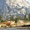
Half Dome
Oakhurst, CA
Half Dome
14.5 mi 23.4 km • 4,457' Up 1358.42 m Up • 4,457' Down 1358.36 m Down
Yosemit…, CA
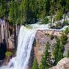
Vernal and Nevada Falls Loop
6.2 mi 10.0 km • 1,999' Up 609.27 m Up • 1,998' Down 608.87 m Down
Yosemit…, CA
Ram Lake via Duck Pass and John Muir Trail
20.0 mi 32.2 km • 3,905' Up 1190.28 m Up • 3,905' Down 1190.21 m Down
Mammoth…, CA


0 Comments