
 Continue with onX Maps
 Continue with Facebook


 Particularly Special Place


 Intermediate
Intermediate
Intermediate
 Intermediate
Land Manager: Ridge to Rivers
 Polecat Loop Hike
6.8 mi 10.9 km • 822' Up 250.62 m Up • 822' Down 250.53 m Down
 Truly Around the Mountain Bogus Basin
12.8 mi 20.6 km • 2,051' Up 625.28 m Up • 2,042' Down 622.39 m Down
 Boise, ID
Ridge Crest - Central Ridge Loop
Boise, ID
Ridge Crest - Central Ridge Loop
2.5 mi 4.0 km • 363' Up 110.64 m Up • 362' Down 110.41 m Down
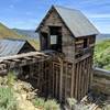
 Adelmann Mine and Lucky Peak
9.5 mi 15.3 km • 2,432' Up 741.17 m Up • 2,435' Down 742.34 m Down
Boise, ID
 Cervidae Peak
4.6 mi 7.5 km • 1,849' Up 563.68 m Up • 1,849' Down 563.62 m Down
Boise, ID
Station Creek to Bald Mountian
7.6 mi 12.2 km • 2,183' Up 665.53 m Up • 2,181' Down 664.92 m Down
Idaho City, ID


0 Comments