
 Continue with onX Maps
 Continue with Facebook


 Particularly Special Place


 Intermediate
Intermediate
Intermediate
 Intermediate
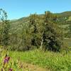
Land Manager: California State Parks - Henry W. Coe State Park
 Henry Coe (Jackson Field, Wasno Ridge, Bowl Trail)
16.1 mi 25.8 km • 2,625' Up 799.95 m Up • 2,624' Down 799.8 m Down

 San Martin, CA
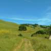
 Coyote Lake and Ridge Hike
6.8 mi 11.0 km • 797' Up 242.86 m Up • 797' Down 242.91 m Down
 Harvey Bear Ranch Hike
11.1 mi 17.8 km • 1,518' Up 462.57 m Up • 1,517' Down 462.45 m Down
San Martin, CA
Middle Ridge Loop
9.3 mi 14.9 km • 1,546' Up 471.13 m Up • 1,545' Down 470.99 m Down
Morgan…, CA
Quicksilver History Loop
8.0 mi 12.9 km • 1,454' Up 443.32 m Up • 1,456' Down 443.8 m Down
Almaden…, CA
Rancho San Vicente Loop
8.4 mi 13.6 km • 672' Up 204.86 m Up • 672' Down 204.74 m Down


 All Clear


0 Comments