
 Continue with onX Maps
 Continue with Facebook


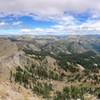
 Particularly Special Place


 Difficult


 Difficult
Land Manager: BLM Nevada - Carson City District Office
 Hunter Lake Loop
4.1 mi 6.5 km • 744' Up 226.88 m Up • 723' Down 220.51 m Down
Jones Whites Creek Loop + Church's Pond (Clockwise)
10.7 mi 17.2 km • 2,391' Up 728.73 m Up • 2,389' Down 728.16 m Down
Mt. Rose Summit Trail
10.1 mi 16.2 km • 2,109' Up 642.78 m Up • 2,108' Down 642.57 m Down
Incline…, NV
Great Trail Epic Course 2017
22.8 mi 36.7 km • 2,981' Up 908.64 m Up • 2,262' Down 689.47 m Down
Hole in the Ground Loop
16.3 mi 26.3 km • 1,939' Up 591.01 m Up • 1,942' Down 591.88 m Down
 Castle Peak Out-and-Back
5.9 mi 9.5 km • 1,768' Up 538.81 m Up • 1,768' Down 538.89 m Down
Truckee, CA


0 Comments