
 Continue with onX Maps
 Continue with Facebook


 Particularly Special Place


 Intermediate
Intermediate
Intermediate
 Intermediate
Land Manager: USFS - Angeles National Forest Office
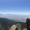
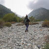
 Cucamonga Peak via Icehouse Canyon
11.4 mi 18.3 km • 4,051' Up 1234.84 m Up • 4,055' Down 1235.91 m Down

 San Ant…, CA
 San Antonio Falls
1.3 mi 2.1 km • 258' Up 78.63 m Up • 258' Down 78.53 m Down
 Bonita Falls Trail
1.5 mi 2.4 km • 374' Up 114.11 m Up • 374' Down 113.92 m Down
 Etiwanda Falls
3.3 mi 5.3 km • 747' Up 227.83 m Up • 751' Down 228.79 m Down
 Mount Williamson
4.4 mi 7.0 km • 1,517' Up 462.44 m Up • 1,516' Down 462.16 m Down
Wrightwood, CA
Mt. Bliss from Monrovia Canyon Park
13.5 mi 21.8 km • 2,804' Up 854.79 m Up • 2,803' Down 854.39 m Down


 Minor Issues


0 Comments