Dogs Off-leash

Features
Fall Colors · Lake · Views · Wildflowers

The trail and its access road may be closed by snow between November and May. Driving to the trailhead requires a vehicle that can ford Sturgis Fork. If not, you'll have to cross the creek on foot and run up the forest road to the trailhead.
Need to Know
The trailhead is at the end of Forest Road #1020-400. The circuit up and around the lake is only 3.4 miles if you can drive to the trailhead. The bridge across Sturgis Fork was removed in 2006. Motorcycles, all-terrain vehicles, and high-clearance cars and trucks can cross the Fork at low water (extremely dangerous or impassable at high water). Otherwise, run across the Fork and up the road, adding 6.6 miles round-trip to the journey.
Description
Miller Lake is a charming, little three-acre lake perched on the side of a ridge above Sturgis Fork to the east of Oregon Caves National Monument. It’s a natural lake that was deepened with an earthen dam years ago by the Thompson Creek Irrigation District. The dam remains, but the old service road to it has been closed. There is now a good singletrack trail that goes to the lake and then circles around it for views from the ridge above.
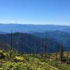
From the trailhead at the end of Forest Road #1020-400, it's only a 0.5 mile run to the old earthen dam on the shore of Miller Lake. From there, the trail goes both right and left—going right (counter-clockwise) makes for an easier climb to the ridge. In 0.8 miles, having gone past some old growth and near some rare Brewer's Spruce, you pass above Little Miller Lake, and in another 0.5 miles, reach the crest of the rocky ridge above the lakes. From here, you have a clear view of Grayback Mountain, the highest point in Josephine County, to the north. From the ridge, the trail plunges, in one long and one short switchback, down to the lake.
If you can drive across the Fork, this is a nice half-day outing to a lake and some good views. If you can’t (or won’t) then it’s a 10 mile round-trip run on road and trail past the lakes to the crest of the ridge.
Flora & Fauna
Brewer's Spruce, Matthews Sugar Pine, White Fir, Douglas Fir tree species, and Oracle and Saddlers Oak, two of the rarer brush species.
Contacts
Shared By:
BK Hope

 Continue with onX Maps
 Continue with Facebook


 Particularly Special Place


 Intermediate

 Red Buttes Loop

 Sterling Mine Ditch Trail Out and Back
 Jackson…, OR


0 Comments