
 Continue with onX Maps
 Continue with Facebook


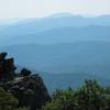
 Particularly Special Place


 Difficult
Difficult
Difficult
 Difficult
Land Manager: USFS - George Washington & Jefferson National Forests
 Bear Wallow-Massanutten Trail Loop
8.7 mi 14.0 km • 1,663' Up 506.82 m Up • 1,678' Down 511.54 m Down

 Dickey Ridge Loop
4.9 mi 7.9 km • 833' Up 253.75 m Up • 829' Down 252.58 m Down
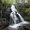
 Overall Run Falls
6.3 mi 10.2 km • 1,348' Up 410.97 m Up • 1,348' Down 410.94 m Down
 Tuscarora to Toms Brook: Shenandoah and GW
55.8 mi 89.8 km • 10,087' Up 3074.59 m Up • 10,088' Down 3074.67 m Down
South and North Mount Marshall Out-and-Back
4.1 mi 6.6 km • 827' Up 252.08 m Up • 827' Down 252.1 m Down
Little Devil Stairs Loop
5.5 mi 8.9 km • 1,453' Up 442.8 m Up • 1,429' Down 435.54 m Down
Washington, VA


0 Comments