Dogs Off-leash

Features
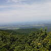
Birding · Fall Colors · Views · Wildlife

Neither end of this trail is easily accessed with standard vehicles. On the eastern, ridge-top end, parking is available via a rough road ascending toward Bother Knob from the Briery Branch Road. Then walk 0.8 miles on a rough Jeep Road to the trail. (There is no space to park here even if you have a Jeep.) On the western, valley end, parking is via a road surrounded by private property (and "No Trespassing" signs) that first requires a stream ford.
Need to Know
This is a popular trail for mountain bikers, so care needs to be taken when hiking this trail, as bikers come down the trail very fast. Not recommended for young children due to bikers and steep trail conditions.
Description
The Sugar Run Trail is one of several trails in this area that steeply climb Shenandoah Mountain in the Flagpole Knob area. From the east, the trail is accessed via a rough Jeep road, with the trailhead only several hundred yards from the
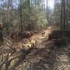
Bother Ridge Trail #1026. The Sugar Run Trail starts out as an old woods road for a short distance, until it reaches a spring and ends. After that, singletrack trail continues, first along a ridge, and then dropping steeply down the ridge until it switches back and descends to a stream called Sugar Run. There, the trail follows another old, unused woods road. After crossing another woods road and several stream crossings, the trail ends at WV Rt 24.
Contacts
Shared By:
Mike Miriello
with improvements
by Jeff Monroe

 Continue with onX Maps
 Continue with Facebook


 Particularly Special Place


 Very Difficult


0 Comments