
 Continue with onX Maps
 Continue with Facebook


 Particularly Special Place


 Intermediate


 Intermediate
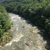
Land Manager: PaDCNR - Ohiopyle State Park
 Ohiopyle Falls & Trails Trilogy Half Marathon
13.8 mi 22.3 km • 1,658' Up 505.43 m Up • 1,658' Down 505.47 m Down
Ohiopyle, PA
Laurel Highlands Trail: Ohiopyle State Park
10.5 mi 16.9 km • 2,139' Up 651.88 m Up • 2,139' Down 652.02 m Down
Ohiopyle, PA
 Laurel Highland 70.5mi Ultra Run
69.7 mi 112.2 km • 8,763' Up 2670.95 m Up • 8,624' Down 2628.72 m Down
 Ragnar Trail Appalachians - Yellow Loop
4.6 mi 7.4 km • 375' Up 114.42 m Up • 374' Down 113.97 m Down
Terra Alta, WV
 Fork Run Loop
8.0 mi 12.9 km • 951' Up 289.81 m Up • 951' Down 289.73 m Down
New Germany Outer Trail Loop
5.2 mi 8.4 km • 696' Up 212.11 m Up • 695' Down 211.95 m Down


0 Comments