
 Continue with onX Maps
 Continue with Facebook


 Particularly Special Place


 Intermediate
Intermediate
Intermediate
 Intermediate
Land Manager: USFS - White River National Forest Office
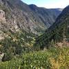
 Grizzly to No Name (Jess Weaver) Loop
11.5 mi 18.5 km • 2,823' Up 860.47 m Up • 2,813' Down 857.46 m Down

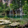
 Hanging Lake
2.6 mi 4.2 km • 1,037' Up 316.17 m Up • 1,037' Down 316.22 m Down
 Glenwoo…, CO
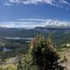
Devil's Causeway Loop
Glenwoo…, CO
Devil's Causeway Loop
10.7 mi 17.2 km • 1,775' Up 541.14 m Up • 1,776' Down 541.24 m Down
Gypsum, CO
Causeway Lake
10.1 mi 16.3 km • 2,383' Up 726.38 m Up • 2,383' Down 726.3 m Down
Gypsum, CO
Red Hill Loop
6.2 mi 10.0 km • 1,139' Up 347.11 m Up • 1,137' Down 346.49 m Down
Carbondale, CO
Colorado Trail (CT)
487.3 mi 784.3 km • 83,178' Up 25352.6 m Up • 81,864' Down 24952.2 m Down
Roxboro…, CO


0 Comments