Dogs Leashed

Features
Birding · Fall Colors · River/Creek · Spring · Views · Wildlife

The trail is closed from dusk to dawn. This trail is in the City of Sandy, and all park rules apply. No overnight camping and no campfires. No motorized vehicles. Mountain bikes are allowed. Dogs must be on leash at all times. No smoking. Please pack out any trash. Keep dogs away from dead salmon carcasses. Swimming is not recommended due to fast cold water, log jams and difficult access for rescue. Report any issues, including illegal camping, to the Sandy Police Department.
Overview
This trail located just off Bluff Road in Sandy provides access to the Sandy River along the recently (2015) constructed, family-friendly
Jim Slagle Loop Trail. This featured run is slightly longer than the Sandy River Trail alone, but that route is mostly an old, steep, and rocky logging road. Taking the
Jim Slagle Loop Trail is much easier, especially for kids or those with weak ankles. It is also shadier in summer heat and provides protection from those running in light rain.
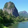
The trail leads you to the shores of the Sandy River where Cedar Creek joins the main channel. The Cedar Creek Fish Hatchery is located upstream from the destination and fall Chinook salmon return to spawn when fall rains provide enough flow in the creek. They are easily visible making redds, and you can see males fighting each other. The Sandy River at the bottom of the trail is remote but can be crowded with folks fishing. Be careful of those casting lines. The water is cold and swift, and the river makes a large "oxbow" (u turn) just downstream with large log and debris jams. Swimming is not recommended.
The trail designer and trail namesake, Jim Slagle, located the trail to highlight the large nurse logs and nurse stumps (trees trees growing out of down logs and stumps), interesting hardwood trees, good views, and the largest western red cedar for miles around. This out-and-back run can also be made into a loop or a figure 8 using the entire part of the
Upper Sandy River Trail and
Sandy River Midway Trail. This trail is a hidden gem in Sandy's largest park.
For one of the best viewpoints and photo opportunity in Oregon, stop at the
Jonsrud Viewpoint 1/2 mile north down Bluff Road after your run. The viewpoint overlooks Sandy River Park, the river's oxbow, Mt. Hood with a large green meadow below, Portland's water source the Bull Run Watershed, Mt. Adams, and Larch Mountain--a spectacular viewpoint! Bonus points for going at sunset for alpenglow on Mt. Hood!
Need to Know
Don't park in front of mailboxes or driveways along Marcy Street or in front of the gate to the park. This run is fun mostly year round (not recommended in occasional winter snowy or icy conditions). It can get a little muddy after lots of rain. It is especially nice in fall when the fall Chinook are running. Keep dogs away from salmon carcasses. Be cautious of casting lines from fishermen. Unfortunately, some fishermen leave fishing line, hooks, beer bottles, and trash. Pack a trash bag to pack some out and you can call yourself and your kids a Sandy River Eco-Helper!
Mountain bikes are allowed on this trail, although the last drop to the river is difficult for bikes.
Head down to the viewpoint after the run and then into Sandy for a great meal, cup of coffee, or cold beer. AntFarm Cafe, Beer Den, and Tollgate Bakery are our favorite post-run stops.
Description
Park at the Sandy High School football field parking lot along Bluff Street across from Marcy Street. Follow Marcy Street to the Sandy River Park entrance behind the vehicle barrier posts. The
Upper Sandy River Trail is an old rocky logging road that heads from the end of Marcy Street down towards the Sandy River. Head down the first part of the trail to where the trail takes a sharp left turn at the bottom of the hill. At this point, turn sharp left and pick up the
Jim Slagle Loop Trail. This trail is preferred to continuing on versus the steeper and rockier
Upper Sandy River Trail.
This trail was designed by a famous Northwest trail designer (and local Sandy resident!) Jim Slagle. It was the last trail he designed before his retirement after 40+ years of trail design including Sandy's other gem,
Tickle Creek Trail and most of the trails in the Mt. St. Helens Monument. The local youth corps AntFarm worked with local trail builder Gene Tilgner to construct the
Jim Slagle Loop Trail in 2015. The first section of trail was an older section of trail that was repaired. There is a rocky, wet area crossing, a large nurse stump with a tree growing out of it, and then a small creek with a culvert at side logs.
Continue north and cross over a large culvert that is another small tributary to the Sandy River. The trail then heads east and at a large cedar snag, there is an intersection. The Jim Slagle Loop turns to the left and going straight ahead is the short
Sandy River Midway Trail that takes you back to the logging road (
Upper Sandy River Trail). Turn left (north) to remain on the
Jim Slagle Loop Trail. The trail crosses another small creek before coming out to a viewpoint towards the river. Along this section of trail is a very large big leaf maple tree that makes a handy snack or lunch stop. The trail then gets into thicker cedar forests with a steep side slope. The trail sides have ferns and "pistol butted" trees growing out of the slopes demonstrating the occasional landslides and loose soil. The trail drops into an open wet area and crosses a boardwalk/bridge made from parts of the old large fallen cedar tree next to the trail. There is private land adjacent to this spot, so please stay on the trail.
Head right after the boardwalk, and you come to a flat bench area of dense second growth western red cedar thicket located above the river. The trail then leads you to the largest tree (western red cedar) around--a great photo op! The trail then comes to the intersection with the upper and lower Sandy River Trail. Take a left to the head to the river.
Before the trail drops to the river, there is a short spur to a viewpoint that shows a small waterfall and the Sandy River beyond. Please do not cut switchbacks that drop to the river as this trail is difficult to maintain and is easily eroded. At the Sandy River, you may see some fishermen and women. The Cedar Creek flows into the main channel just upstream. There is a fish hatchery further up Cedar Creek which makes this confluence a popular destination for returning spawning salmon and folks fishing and fish watching in fall. A separate trail comes down to this point from the fish hatchery. The trail peters out at the river, but fishing trails lead downstream. Be careful, these trails are not designed or maintained, and can be unstable and adjacent to fast moving water. The ice cold Sandy River makes an "oxbow" (u shaped) turn just downstream. This causes fast, changing currents as well as large log debris jams.
This trail is a good place to come see salmon spawning in the fall in Cedar Creek after a good fall rain. There are also some spent dead salmon on the river bank that can attract bears and other wildlife, so keep an eye out and do not let your dog get anywhere near the carcasses if you don't want an emergency veterinarian trip. Once you head back up the trail, I recommend taking the
Jim Slagle Loop Trail to return. It is amazing to have such a gem of a destination so close to Sandy.
Flora & Fauna
The trail has a variety of hardwoods including alder, big leaf maple and vine maple. Douglas fir and western hemlock predominate, and small and large (spectacularly large) western red cedars are found in the areas near water. The trail can have deer, coyote, and the rarer larger wildlife like bears when the salmon are running. Birds are abundant including blue herons, ducks, osprey and an occasional bald eagle. Sword ferns, deer ferns, maidenhair ferns, Oregon grape, salal, thimble berry, salmon berry, and stinging nettle are found on the trail. Avoid the nettle. Stinky skunk cabbage is found in wet areas.
History & Background
This area is near the historic Oregon Trail along one of the Sandy River crossings. Interpretive signs about the area are found at the
Jonsrud Viewpoint. The City of Sandy just acquired more forest land and the Cedar Ridge Middle School east of the Sandy River Park and will be developing additional connector trails to this area.
Contacts
Shared By:
Kathleen Walker

 Continue with onX Maps
 Continue with Facebook


 Particularly Special Place


 Intermediate

 Oxbow Highlights

 Grouse Vista - Sturgeon Rock - Silver Star Loop
 Venersborg, WA
 Pup Creek Falls Out and Back


0 Comments