Dogs Unknown

Features
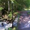
River/Creek · Views
Description
From Yarlovo, head east out of town and at the fork, take the red marked trail to the left. You'll climb for the next 7km initially through fields then into the forest. The surface has a mix of rock and dirt and is a wash when it rains. As you reach the top of the climb, there are a series of steep up and down sections before you're dumped out into the village of Iarema. Run straight down the street where you'll meet the main road, turn to the left and follow the road for 1 kilometer. The road will turn right then back to the left, but you continue straight after the right hand turn into an open field. There the trail speeds downhill on a forested track, when you reach the T junction with a lake. Stay to the left as the trail parallels a river. Again, you'll find yourself on a paved road; follow it for about 2 kms before you see the red sign pointing you up a gravel road that will lead to Brezite.
Shared By:
Jonathan Salibra

 Continue with onX Maps
 Continue with Facebook


 Particularly Special Place


 Intermediate


0 Comments