
 Continue with onX Maps
 Continue with Facebook


 Particularly Special Place


 Difficult
Difficult
Difficult
 Difficult
Land Manager: BLM Utah - Grand Staircase Escalante National Monument
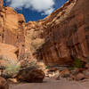
 Little Death Hollow to Wolverine Canyon
17.9 mi 28.8 km • 2,564' Up 781.39 m Up • 2,449' Down 746.6 m Down

 Escalante, UT
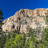
Strike Valley Overlook and Upper Muley Twist Canyon
Escalante, UT
Strike Valley Overlook and Upper Muley Twist Canyon
15.8 mi 25.4 km • 1,344' Up 409.68 m Up • 1,344' Down 409.61 m Down
Escalante, UT
The Box Trail
8.9 mi 14.4 km • 1,725' Up 525.81 m Up • 363' Down 110.57 m Down
Escalante, UT
 Burro Wash
6.6 mi 10.7 km • 552' Up 168.33 m Up • 552' Down 168.34 m Down
Loa, UT
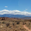
Capital Reef Extravaganza
26.8 mi 43.1 km • 6,105' Up 1860.75 m Up • 6,105' Down 1860.94 m Down
Loa, UT
 Escalante River: Escalante Town to Highway 12 Bridge
14.6 mi 23.5 km • 1,334' Up 406.64 m Up • 1,939' Down 590.9 m Down


0 Comments