
 Continue with onX Maps
 Continue with Facebook


 Particularly Special Place


 Intermediate
Intermediate
Intermediate
 Intermediate
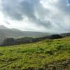
Land Manager: California State Parks - China Camp
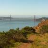
 Golden Gate Bridge Overlook Out-and-Back
5.3 mi 8.5 km • 1,000' Up 304.86 m Up • 999' Down 304.44 m Down

 Sausalito, CA
 Miller/Knox Regional Shoreline Kid Friendly Loop
3.0 mi 4.9 km • 68' Up 20.63 m Up • 68' Down 20.7 m Down
Tennessee Valley: Ridge Trail to Coast Loop
5.4 mi 8.7 km • 924' Up 281.5 m Up • 936' Down 285.36 m Down
Tamalpa…, CA
Mt. Tam Wild Boar Half Marathon
11.4 mi 18.4 km • 1,446' Up 440.65 m Up • 1,441' Down 439.26 m Down
Mill Va…, CA
Romancing the Island
13.7 mi 22.0 km • 1,511' Up 460.56 m Up • 1,491' Down 454.31 m Down
Tiburon, CA
Romancing the Island 10K
6.8 mi 11.0 km • 727' Up 221.61 m Up • 705' Down 214.81 m Down
Tiburon, CA


0 Comments