
 Continue with onX Maps
 Continue with Facebook


 Particularly Special Place


 Intermediate

 Intermediate
 James Peak to Rollins Pass Loop
21.3 mi 34.3 km • 4,878' Up 1486.84 m Up • 4,879' Down 1487.14 m Down
 Winter…, CO
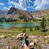
 Three Crater Lakes Trail
6.9 mi 11.1 km • 1,801' Up 548.96 m Up • 1,799' Down 548.44 m Down
High Lonesome Loop
15.7 mi 25.2 km • 3,162' Up 963.89 m Up • 3,162' Down 963.86 m Down
Nederland, CO
Hessie to Lost Lake
4.4 mi 7.1 km • 860' Up 262.21 m Up • 860' Down 262.12 m Down
Nederland, CO
Diamond Lake
5.4 mi 8.6 km • 1,100' Up 335.27 m Up • 1,101' Down 335.66 m Down
Nederland, CO
Columbine Lake Out-and-Back
6.4 mi 10.3 km • 978' Up 298 m Up • 978' Down 297.96 m Down
Fraser, CO


0 Comments