
 Continue with onX Maps
 Continue with Facebook


 Particularly Special Place


 Difficult
Difficult
Difficult
 Difficult
Land Manager: USFS - Okanogan & Wenatchee National Forest Office
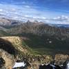
 Pasayten Wilderness Loop
42.3 mi 68.1 km • 5,789' Up 1764.44 m Up • 5,788' Down 1764.12 m Down
 Winthrop, WA
 Tiffany Lake and Honeymoon Pass
4.5 mi 7.2 km • 823' Up 250.73 m Up • 823' Down 250.76 m Down
Tonasket, WA
Pacific Crest Trail: Harts Pass to Rainy Pass
31.1 mi 50.0 km • 4,484' Up 1366.86 m Up • 5,765' Down 1757.22 m Down
Diablo, WA


0 Comments