
 Continue with onX Maps
 Continue with Facebook


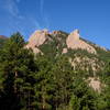
 Particularly Special Place


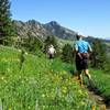
 Intermediate

 Intermediate
 Walker Ranch
8.0 mi 12.9 km • 1,527' Up 465.57 m Up • 1,523' Down 464.22 m Down
 Coal Creek, CO
 Green Mountain West Ridge
3.9 mi 6.3 km • 633' Up 193.08 m Up • 634' Down 193.23 m Down
Switzerland Trail - Bald Mountain Loop
5.2 mi 8.3 km • 797' Up 242.92 m Up • 794' Down 241.94 m Down
Shanahan Ridge
3.9 mi 6.3 km • 831' Up 253.22 m Up • 831' Down 253.4 m Down
Spring Brook / Goshawk Double Loop
8.3 mi 13.3 km • 1,065' Up 324.5 m Up • 1,065' Down 324.47 m Down
Superior, CO
Indian Peaks Traverse (IPT)
71.2 mi 114.6 km • 9,173' Up 2796.02 m Up • 5,813' Down 1771.92 m Down
Boulder, CO


 Minor Issues


0 Comments