Dogs Leashed

Features
Birding · Fall Colors · River/Creek

This park is open year-round and there are no fee or permit requirements.
Need to Know
There are 4 primitive campsites in the park, available on a first-come, no reservation basis; maximum stay is 3 days. Each site has a fire ring, but you must provide your own wood; no wood in the park may be burned. There is no running, potable water in the park. Porta-potties are available May through October. There is no garbage service - so pack it, pack it out. The main trails, which follow old road prisms, are usually mowed during the summer months to ease access. Signage along these trails is minimal.
Description
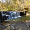
Today's 850 acre Cannon Wilderness Park is administered by Rice County. It came into being in 1976 thanks to the efforts of local volunteers, land owners, and county officials. This park preserves remnants of the Big Woods ecosystem from lush lowlands to tree covered uplands. The Cannon River itself is one of six designated Wild and Scenic Rivers in Minnesota.
There are two trailheads in the park. The East Trailhead accesses a 1.2 mile trail to the river. The West Trailhead accesses two linked loops which are the longest trails in the park.
From the West Trailhead, the trail goes past a footbridge over the river. This bridge leads to the only campsite on the east side of the river. Shortly thereafter, the trail splits at the first loop. Go right (east) here to continue on along the river and under some powerlines to the start of the second loop. Go right (east) again here to continue on along the river. NOTE: Parts of the second loop may not be mowed.
About 2 miles from the trailhead, the second loop will bend inland from the river. Pay attention in here as the left turn (to the southwest) that puts you on the old (possibly unmowed) road back to the trailhead may be obscured by vegetation. If you find yourself on an obvious game trail, you've missed the old road.
Once you've found the return road, follow it southwest up and over a slight rise to the end of the second loop. Continue on under the powerlines, then veer right to continue of the inland side of the first loop. Soon you'll be back just short of the bridge and soon thereafter back at the trailhead.
Contacts
Shared By:
BK Hope

 Continue with onX Maps
 Continue with Facebook


 Particularly Special Place


 Easy/Intermediate


0 Comments