
 Continue with onX Maps
 Continue with Facebook


 Particularly Special Place


 Easy/Intermediate

 Easy/Intermediate
Land Manager: MA DCR - Kenneth M. Dubuque Memorial Forest
 Mount Greylock Summit Loop
6.6 mi 10.7 km • 2,251' Up 686.23 m Up • 2,246' Down 684.66 m Down
 Adams, MA
Bellows Pipe to Mt Greylock Summit
Adams, MA
Bellows Pipe to Mt Greylock Summit
5.8 mi 9.4 km • 2,231' Up 679.9 m Up • 2,231' Down 679.86 m Down
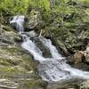
 Sanderson Brook Falls Trail
2.0 mi 3.2 km • 238' Up 72.54 m Up • 239' Down 72.79 m Down
Northfield Mountain Trails
11.3 mi 18.3 km • 1,913' Up 583.11 m Up • 1,912' Down 582.9 m Down
 Ledges/Overbrook Loop
2.7 mi 4.3 km • 894' Up 272.42 m Up • 898' Down 273.68 m Down
Goat Peak Out-and-Back
0.9 mi 1.5 km • 277' Up 84.39 m Up • 277' Down 84.49 m Down
Eastham…, MA


0 Comments