This trail has a few places where you can start: Pebble Creek Ski Area, Inkom Pass (via
South Fork Inman Creek Canyon Trail and the Upper Jackson Creek Trail), or Big Springs Campground. The trail follows a wider track that accommodates ATVs and dirt bikes. From Pebble Creek Ski Area, the trail heads north until it crosses Jackson Creek. The trail then heads up Jackson Creek Canyon to Inkom Pass. This is a steep climb, and will probably be difficult for most people to run, but hiking is okay. The footing here is rocky in many places. From Inkom Pass, the trail drops down towards Big Springs Campground in a nice gradual drop. This section is nice and shady, passing under a lovely canopy of pines, aspens, fir, and spruce trees.
The route has signs that say "Boundary Trail 072" throughout the route, but the USFS maps label this trail the North Boundary Trail and assign the number 244 to it.
Route breakdown going eastbound (start by heading north) from Pebble Creek Ski area to Big Springs Campground
0: Pebble Creek Ski Area
0.1: Green Canyon Creek crossing (bridge)
0.8: Unnamed creek (easy crossing)
1.9: Jackson Creek (easy crossing) 1300 foot climb after
3.8: Inkom Pass (Junct. with
Inkom Pass Loop #242 and
Upper Jackson Creek Trail #243
4.4: Small creek crossing. There may be water here early in the season
5.6 Small creek crossing
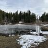
Around 6: There is a series of deep muddy ponds in the road. They probably dry out by mid to late summer
6.3: There is a tricky junction with a jeep road. Take the right fork
6.8: Creek crossing
7.2: Creek crossing
7.4 Trail joins up with Big Canyon Road.
Big Springs Campground has a water spigot, camp sites, pit toilets. There is also a cabin near by called Pebble Creek Guard Station, it can be reserved on Recreation.gov for 60$ per night.

 Continue with onX Maps
 Continue with Facebook


 Particularly Special Place


 Intermediate/Difficult

 4.5 (2)


0 Comments