Trail Run Project Logo

Marshlands Conservation Area and beyond.


Your Rating: Rating Rating Rating Rating Rating      Clear Rating
Your Difficulty:
Your Favorites: Add To-Do · Your List
Zoom in to see details
Map Key

3.9

Miles

6.3

KM

100%

Runnable

331' 101 m

High

254' 77 m

Low

81' 25 m

Up

12' 4 m

Down

0%

Avg Grade (0°)

3%

Max Grade (1°)

Dogs Leashed

Description

Since 1971, the Rideau Trail Association has established, maintained and encouraged low-impact, self-propelled use of the Rideau Trail, a 387 km network of interconnected trails between the City of Kingston and the City of Ottawa located in the general area of the Rideau Canal and its tributary waters.

This trail continues the Rideau Trail (RT) from the Rideau Trail: Marshlands Conservation Area Segment or Rideau Trail: Urban Kingston Alternate Route. The RT then angles L on Greenview Dr, then after 200 m turns L (N) at a T junction onto Queen Mary Rd, which it follows to cross Bath Rd at lights.

The RT goes ahead (N) on Queen Mary Rd, through parkland following utility poles, and after 400 m it passes a S junction, and then a N junction, with the Helen A. Henderson Loop. The RT passes an access R from Sherwood Dr, and goes through a gate and L to wind through woods to Parkway, which it follows N. It crosses Princess St at lights and goes L (W) for 200 m on the road. Opposite the Ambassador Hotel it bears R to follow an old road to the S platform of Kingston VIA Rail Station. The RT goes R on the platform and via an underpass, open only during business hours, to the main station building.

The RT goes L from the station on its approach road, and crosses John Counter Blvd. It angles L 50 m across open land, follows Purdy's Court for 200 m, then goes R on Purdy's Mill Rd for 150 m and L through the main entrance of Cataraqui Cemetery. The RT goes N on Maple Av for 250 m, then turns L on Beech Av, where on the L are the graves of Sir John A Macdonald and Sir Alexander Campbell. It then goes R (N) on Evergreen Path and R (N) for 1 km on West Av, passing the RT memorial bench overlooking a memorial garden and pond.

It goes L on Spruce Av and out of the Cemetery's North Gate, turning R onto Sydenham Rd. The RT goes N for 500 m on Sydenham Rd, past a convenience store R, the last such facility on the RT until Sydenham. The trail then connects with K&P Trail (Rural Kingston Segment).

Contacts

Land Manager: City of Kingston
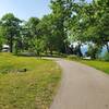
Shared By:

Ali Ryder

Trail Ratings

  3.0 from 1 vote

#12

in Kingston

#33857

Overall
  3.0 from 1 vote
5 Star
0%
4 Star
0%
3 Star
100%
2 Star
0%
1 Star
0%
Trail Rankings

#12

in Kingston

#227

in Ontario

#33,857

Overall
2 Views Last Month
55 Since Nov 15, 2020
Easy/Intermediate Easy/Intermediate

0%
100%
0%
0%
0%
0%

0 Comments

Current Trail Conditions

Unknown
Add Your Check-In

Check-Ins

none
Welcome

Join the Community

Create your FREE account today!
Already have an account? Login to close this notice.

Get Started