
 Continue with onX Maps
 Continue with Facebook


 Particularly Special Place


 Difficult

 Difficult
 Alpe Sattal
4.0 mi 6.4 km • 2,558' Up 779.79 m Up • 2,558' Down 779.73 m Down
Matterhorn Trail
5.4 mi 8.7 km • 3,088' Up 941.3 m Up • 55' Down 16.89 m Down
 Zermatt, CH
Zermatt Lollipop
Zermatt, CH
Zermatt Lollipop
3.6 mi 5.8 km • 859' Up 261.88 m Up • 858' Down 261.64 m Down
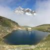
 Seven Lakes with Matterhorn Reflections
9.0 mi 14.5 km • 3,200' Up 975.27 m Up • 967' Down 294.87 m Down
Zermatt, CH
Zermatt Marathon
26.7 mi 43.0 km • 6,350' Up 1935.55 m Up • 1,485' Down 452.65 m Down
Sankt N…, CH
 TOR330_2022_VAR_OYACE
213.9 mi 344.2 km • 78,549' Up 23941.8 m Up • 78,525' Down 23934.3 m Down
Martign…, CH


0 Comments