Dogs Off-leash

Features
Birding · Views · Wildflowers · Wildlife
Description
The trail continues along old ranching roads through the vast oceans of sagebrush and ryegrass. After a few miles, it crosses the Clover Three Creek Road, the major thoroughfare for this area. This is an excellent place to resupply if you have a friend to drop off some rations for you.
To the east of this section of the trail lies the Saylor Creek Air Force Range, which is a live-ammunition testing area. You'll certainly see fighters and bombers flying overhead, and you may even hear or see explosions in the distance where advanced weapons testing is taking place.
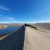
The trail meanders over rolling hills, so there is some elevation gain and loss, but overall you are continuing your gradual descent toward the Snake River, the low point for this section of the trail.
Flora & Fauna
Sagebrush, ryegrass, wildflowers in the spring, bighorn sheep, jackrabbits, mule deer, antelope, hawks, vultures.
Contacts
Shared By:
Keaton Reed

 Continue with onX Maps
 Continue with Facebook


 Particularly Special Place


 Easy
Easy


0 Comments