 Race - Jun 6, 2020
Dogs No Dogs

Features
Spring · Views · Wildflowers · Wildlife
Overview
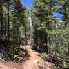
The North Fork course is 100% dirt, mainly singletrack and some doubletrack and dirt road. Most of the footing is quite good, but there are some steep sections and some rocky sections as you would expect in a trail race. There are several big climbs and downhills, but most of the climb is not extremely steep. Sections along the ridges and along Buffalo Creek are rolling and mostly gentle. Most of the course is in pine forest, but there are a few burn areas that are open and unshaded. The burn areas offer some beautiful views of the high mountains in the distance.
The altitude ranges from 6,700 to 8,100 feet for the 50K and up to 8,500 feet for the 50 Mile. The elevation gain is about 3,800 feet for the 50K and 6,800 feet for the 50 Mile.
So how hard is it?? Well, that depends on your experience, level of training and ability. If you are a strong runner with experience on mountain trails, North Fork is a relatively easy race by mountain trail standards and quite runable. If you are new to ultramarathons, not experienced on mountain trails, not used to altitude and/or not well trained, the race will feel hard. There are a number of long climbs, and downhills on trails are slower than on the roads. Most people will walk much of the uphill. If the weather is hot, it will seem harder. Be sure to study the elevation profile to get a feel for how much up and down there is.
Need to Know
Parking is in the open field behind and below the Bippy Community Hall Building. Turn left on the dirt track into the field immediately as you turn onto Buffalo Creek Road/FS 543.
DO NOT park in the gravel Buffalo Creek Recreation Area parking lot, which is beyond the Community Hall. Staff will start directing parking at 5:15 a.m. PLEASE DO NOT ARRIVE BEFORE 5:15!
If you do get there before the parking staff, stay in your car on Buffalo Creek Road near the entrance so you can then park where you are directed by the staff.
Description
The race starts and finishes at the Buffalo Park Improvement Association (BPIA or "Bippy") Community Hall in Buffalo Creek, Colorado. Directions can be found in the race information. The start is on Buffalo Creek Road at the edge of the trees at the far end of the Community Hall parking lot. The first .9 mile rolls mostly downhill on Buffalo Creek Road along Buffalo Creek. Then the course turns left onto
Nice Kitty Trail for a big 3.9-mile rolling climb (with some downhill breaks) through the starkly beautiful Buffalo Creek burn scar. At the top of the climb, runners turn left onto Buffalo Burn Trail for .3 mile to the Colorado Trail and the Colorado Trail Water Station at 5.1 miles. This station is water only, as it is only 3 more miles to the first full aid station.
From the water station, runners turn right onto Colorado Trail, a gently uphill doubletrack. In one mile the trail turns right and narrows to singletrack at the Little Scraggy parking area. There is a bathroom a few steps from the trail at Little Scraggy. Runners then follow the Colorado Trail for 2 gently rolling miles to Shinglemill Trail, where they turn right and run .2 mile downhill and across FS 550 to the Shinglemill aid station at 8.2 miles. Stock up on food and water here, as it is 6.5 miles to the next aid station.
Runners then turn around at the aid station and go back up Shinglemill Trail to Colorado Trail, where they turn right and follow Colorado Trail for 3.6 miles. This section is rolling, mostly up for the first half, reaching one of the high points on the 50K course, and then mostly down to the right turn onto Tramway Creek Trail. The last part of the CT section and the first part of Tramway have some of the most difficult footing on the course, with lots of rocks and roots. Tramway is 1.4 miles of downhill, crossing the FS 550 road halfway down and ending at Buffalo Creek Road/543. Then turn left on Buffalo Creek, a lovely, gentle doubletrack, and go 1 mile to its end at a big iron gate at Forest Service
Road 550. The course turns right for .1 mile on FS 550 and then left onto Meadows Group Campground Road for .1 mile to the Meadows aid station at mile 14.7 at the Colorado Trail's Buffalo Trailhead.
From Meadows, the 50K course heads back out the Meadows Campground Road .1 mile to FS 550, where runners turn left on 550 and run on the road (turning right toward Bailey on 550 at the Y in .4 mile where 543 goes straight/left toward Wellington Lake) for .8 mile to where Redskin Creek Trail crosses the road. Runners turn right on Redskin Creek for a .8-mile climb on nice singletrack to a parking area at Gashouse Gulch trailhead. Runners continue straight (don't turn left or go through the fence into the parking area) onto Gashouse Gulch Trail for 1.7 miles of mostly downhill, some through the Buffalo Creek burn scar, to the Buffalo Creek aid station at 18.2 miles.
From Buffalo Creek aid station, the last big climb begins up Baldy Trail. The climb is 3.5 miles, but it is rolling and has some flattish breaks and becomes more level in the last half mile. At the wide Gashouse Gulch trail junction, the course turns right on Gashouse and continues .6 mile to the end of the trail at
Miller Gulch doubletrack. Runners turn right on
Miller Gulch and go .2 mile to the Homestead aid station at 22.7 miles.
Runners then do "Charlie's Loop." Runners turn left on Homestead for .9 mile to the Skipper/Strawberry Jack junction, turn right on Homestead for another 1.4 miles, and then turn right on
Charlie's Cutoff for 1.4 miles of mostly uphill back to
Homestead Trail. The course then turns left on Homestead for .2 mile back to the Homestead aid station at 26.6 miles.
The 5.6-mile run from Homestead to the finish is almost (but not entirely!) all downhill. Runners go down
Miller Gulch for 2 miles and then turn right onto
Sandy Wash Trail for 2.9 miles to the end of the trail at Buffalo Creek Road/543. left onto Buffalo Creek for the last .7 mile
Contacts
Shared By:
Andrew Hodges

 Continue with onX Maps
 Continue with Facebook


 Particularly Special Place


 Difficult

 Buffalo Creek Loops

 Deckers, CO
 Little Scraggy Loop


0 Comments