
 Continue with onX Maps
 Continue with Facebook


 Particularly Special Place


 Easy/Intermediate
Easy/Intermediate
Easy/Intermediate
 Easy/Intermediate
Land Manager: USFS - Angeles National Forest Office
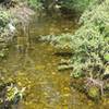
 Sturtevant Falls
3.4 mi 5.4 km • 639' Up 194.74 m Up • 639' Down 194.85 m Down

 Arcadia, CA
Henninger Flats
Arcadia, CA
Henninger Flats
6.1 mi 9.9 km • 1,550' Up 472.46 m Up • 1,550' Down 472.4 m Down
Mt. Lowe Railway Ruins
5.3 mi 8.5 km • 1,344' Up 409.63 m Up • 1,344' Down 409.51 m Down
Altadena, CA
 Mt. Lowe Historic Railway Tour
11.5 mi 18.4 km • 2,686' Up 818.71 m Up • 2,686' Down 818.78 m Down
El Prieto to Brown Mountain Loop
8.2 mi 13.2 km • 1,254' Up 382.3 m Up • 1,254' Down 382.32 m Down
Three Peak Circuit
7.9 mi 12.7 km • 2,324' Up 708.5 m Up • 2,322' Down 707.7 m Down


0 Comments