Check the self-service pay station near the entrance for fees and regulations.
Description
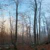
This trail leads along a primitive dirt path through thick forest. The trail starts at the main forest service road heading northeast along a relatively level path. Gradually the trail climbs the knob, though there are a few steeper sections. The trail ends at the junction with Brock Creek #45.
This is primarily considered an OHV trail but is also open to motos, mountain bikes, horses, and foot traffic. Please stay alert while using this trail and be respectful of all users.
We use cookies to improve your browsing experience, to show you
personalized content, and for statistical purposes. By continuing
to navigate our website, you accept our use of cookies. Read our
Privacy Policy to learn more.

 Continue with onX Maps
 Continue with Facebook


 Particularly Special Place


 Intermediate


0 Comments