
 Continue with onX Maps
 Continue with Facebook


 Particularly Special Place


 Intermediate
Intermediate
Intermediate
 Intermediate
Land Manager: USFS - Chattahoochee-Oconee National Forest
 Georgia Sky to Summit 25K Trail Race
15.2 mi 24.5 km • 3,224' Up 982.75 m Up • 3,224' Down 982.67 m Down

 Mountai…, GA
Beech Creek Trail to Big Scaly Mountain
Mountai…, GA
Beech Creek Trail to Big Scaly Mountain
9.9 mi 15.9 km • 2,649' Up 807.37 m Up • 2,650' Down 807.68 m Down
 Shadows of the South 100 Mile
99.2 mi 159.7 km • 18,047' Up 5500.83 m Up • 18,204' Down 5548.71 m Down
Franklin, NC
Standing Indian (Nantahala Headwaters) Loop
21.9 mi 35.3 km • 3,960' Up 1206.92 m Up • 3,972' Down 1210.8 m Down
Franklin, NC
AT: Winding Stair Gap to Nantahala Outdoor Center (NOC)
27.8 mi 44.8 km • 5,316' Up 1620.42 m Up • 7,280' Down 2219.01 m Down
Franklin, NC
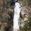
 Lower Whitewater Falls Hike
4.3 mi 6.9 km • 843' Up 257.09 m Up • 844' Down 257.11 m Down
Walhalla, SC


0 Comments