
 Continue with onX Maps
 Continue with Facebook


 Particularly Special Place


 Difficult
Difficult
Difficult
 Difficult
Land Manager: USFS - Payette National Forest Office
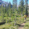
 Tyndall Creek Out-and-Back
11.2 mi 17.9 km • 1,602' Up 488.32 m Up • 1,602' Down 488.34 m Down
 Cascade, ID
 Snowslide Lake Out and Back
3.3 mi 5.3 km • 1,347' Up 410.48 m Up • 1,346' Down 410.36 m Down
 Hum Lake Out and Back
6.7 mi 10.7 km • 2,228' Up 679.04 m Up • 2,228' Down 679.08 m Down
Crestline Trail (#109)
15.6 mi 25.1 km • 2,745' Up 836.69 m Up • 4,381' Down 1335.45 m Down
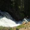
Goose Creek Falls
3.1 mi 5.0 km • 759' Up 231.47 m Up • 759' Down 231.39 m Down
 McCall, ID
Granite Mountain Lookout
McCall, ID
Granite Mountain Lookout
5.6 mi 9.0 km • 1,732' Up 527.84 m Up • 1,732' Down 527.8 m Down
McCall, ID


0 Comments