
 Continue with onX Maps
 Continue with Facebook


 Particularly Special Place


 Easy/Intermediate

 Easy/Intermediate
Land Manager: USFS - Nez Perce & Clearwater National Forests Office
 Feather Creek Loops
16.9 mi 27.2 km • 1,763' Up 537.22 m Up • 1,752' Down 533.95 m Down
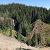
Elk Creek Falls
2.8 mi 4.5 km • 579' Up 176.53 m Up • 579' Down 176.5 m Down
 Orofino, ID
 Grandmother and Grandfather Mountains
7.9 mi 12.8 km • 1,397' Up 425.9 m Up • 1,398' Down 426.02 m Down
Clarkia, ID


0 Comments