
 Continue with onX Maps
 Continue with Facebook


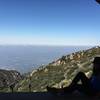
 Particularly Special Place


 Intermediate/Difficult
Intermediate/Difficult
Intermediate/Difficult
 Intermediate/Difficult
Land Manager: USFS - Angeles National Forest Office
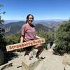
 Strawberry Peak Out and Back
7.1 mi 11.5 km • 1,596' Up 486.53 m Up • 1,597' Down 486.64 m Down

 La Caña…, CA
 Big Tujunga to Strawberry Potrero and Josephine Peak
15.8 mi 25.4 km • 2,744' Up 836.37 m Up • 2,744' Down 836.22 m Down
Mt. Lowe Summit Loop from Cobb Estate
13.0 mi 20.9 km • 3,796' Up 1157.16 m Up • 3,797' Down 1157.2 m Down
El Prieto to Brown Mountain Loop
8.2 mi 13.2 km • 1,254' Up 382.3 m Up • 1,254' Down 382.32 m Down
Mt Lukens
8.8 mi 14.2 km • 3,329' Up 1014.7 m Up • 3,328' Down 1014.48 m Down
La Cres…, CA
Angeles National Forest 50K
32.0 mi 51.5 km • 7,172' Up 2185.89 m Up • 7,172' Down 2186.15 m Down
Sierra…, CA


0 Comments