
 Continue with onX Maps
 Continue with Facebook


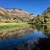
 Particularly Special Place


 Intermediate

 Intermediate
 Card Canyon Loop
7.3 mi 11.7 km • 2,374' Up 723.55 m Up • 2,382' Down 726.06 m Down
 North L…, UT
 Crimson Trail/Riverside Nature Trail Loop
4.1 mi 6.5 km • 1,435' Up 437.41 m Up • 1,436' Down 437.67 m Down
North L…, UT
Green Canyon
9.5 mi 15.3 km • 1,124' Up 342.68 m Up • 1,124' Down 342.63 m Down
North L…, UT
 Temple Fork Sawmill Out and Back
5.4 mi 8.7 km • 666' Up 203.04 m Up • 666' Down 202.97 m Down
Smithfield, UT
Bear 100
104.4 mi 167.9 km • 20,899' Up 6369.87 m Up • 19,810' Down 6038.2 m Down
River H…, UT
Providence Canyon Singletrack to Second Waterfall
8.0 mi 12.8 km • 1,779' Up 542.19 m Up • 1,779' Down 542.3 m Down
Providence, UT


0 Comments