
 Continue with onX Maps
 Continue with Facebook


 Particularly Special Place


 Intermediate


 Intermediate
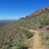
Land Manager: Texas Parks and Wildlife - Franklin Mountains State Park
 Sunset Loop
8.3 mi 13.4 km • 1,523' Up 464.15 m Up • 1,489' Down 453.87 m Down
 Lower Sunset Alternate Loop
4.9 mi 7.9 km • 771' Up 235.02 m Up • 752' Down 229.23 m Down
 Ron Coleman Trail
3.7 mi 6.0 km • 1,697' Up 517.32 m Up • 1,416' Down 431.66 m Down
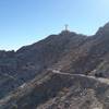
El Paso, TX
Mount Cristo Rey
4.6 mi 7.4 km • 630' Up 191.94 m Up • 629' Down 191.79 m Down
Don Rayo
4.3 mi 6.9 km • 842' Up 256.79 m Up • 836' Down 254.88 m Down
Ciudad…, MX
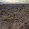
Kilbourne Hole
7.8 mi 12.5 km • 361' Up 110.15 m Up • 364' Down 110.98 m Down


0 Comments