
 Continue with onX Maps
 Continue with Facebook


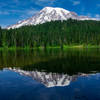
 Particularly Special Place


 Difficult
Difficult
Difficult
 Difficult
Local Club: Washington Trails Association
Apr 15, 2024: 5 ways to connect with WTA this spring
Apr 12, 2024: Young hikers build interactive art exhibit to educate about trails
Apr 11, 2024: Hiker Headlines: Olympic National Park backcountry permits, prescribed burns, partial trail closure
Land Manager: National Park Service - Mount Rainier National Park
 Gobblers Knob/Lake George
10.7 mi 17.2 km • 2,466' Up 751.65 m Up • 2,466' Down 751.51 m Down

 Eatonville, WA
 Eagle Peak
6.7 mi 10.8 km • 2,880' Up 877.86 m Up • 2,880' Down 877.83 m Down
Eatonville, WA
 Nisqually Vista
1.2 mi 1.9 km • 175' Up 53.36 m Up • 175' Down 53.22 m Down
Eatonville, WA
High Lakes Loop
2.7 mi 4.4 km • 563' Up 171.57 m Up • 561' Down 171 m Down
Eatonville, WA
Echo Rock and Observation Rock
12.4 mi 19.9 km • 4,289' Up 1307.22 m Up • 4,289' Down 1307.34 m Down
Eatonville, WA
 Tolmie Peak
6.1 mi 9.8 km • 1,348' Up 410.88 m Up • 1,348' Down 410.83 m Down
Eatonville, WA


0 Comments