
 Continue with onX Maps
 Continue with Facebook


 Particularly Special Place


 Difficult
Difficult
Difficult
 Difficult
Land Manager: USFS - Hood Canal Ranger District
 Mt. Rose Loop Trail #814
6.5 mi 10.5 km • 3,488' Up 1063.26 m Up • 3,488' Down 1063.16 m Down
 Lake of the Angels (Putvin Trail #813) Out and Back
6.5 mi 10.4 km • 3,280' Up 999.75 m Up • 3,279' Down 999.43 m Down
 Seabeck, WA
 Enchanted Valley Route
35.2 mi 56.7 km • 4,414' Up 1345.51 m Up • 4,414' Down 1345.47 m Down
Quinault, WA
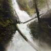
 Murhut Falls Trail #828
1.5 mi 2.5 km • 236' Up 72.05 m Up • 241' Down 73.56 m Down
Brinnon, WA
Royal Basin Out and Back
15.6 mi 25.1 km • 3,262' Up 994.15 m Up • 3,264' Down 994.76 m Down
Sequim, WA
Mount Walker Loop
7.9 mi 12.7 km • 2,187' Up 666.45 m Up • 2,185' Down 666.12 m Down
Quilcene, WA


0 Comments