
 Continue with onX Maps
 Continue with Facebook


 Particularly Special Place


 Easy/Intermediate


 Easy/Intermediate
Land Manager: City of Boulder, Colorado - Parks and Recreation
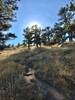
 Hogback Ridge Loop
2.1 mi 3.4 km • 740' Up 225.45 m Up • 739' Down 225.39 m Down
 Anne U. White Trail
3.3 mi 5.3 km • 444' Up 135.23 m Up • 444' Down 135.29 m Down
Boulder, CO
Teller Farm - The Tank
11.0 mi 17.8 km • 517' Up 157.67 m Up • 517' Down 157.68 m Down
Welcome to Chautauqua
1.3 mi 2.2 km • 436' Up 132.79 m Up • 434' Down 132.4 m Down
Marshall Mesa to Spring Brook Loop
11.1 mi 17.9 km • 889' Up 271.11 m Up • 889' Down 271.02 m Down
Superior, CO
Flagstaff Summit Loop
2.4 mi 3.9 km • 346' Up 105.4 m Up • 337' Down 102.81 m Down
Boulder, CO


0 Comments