Dogs Unknown

Features
Birding · Fall Colors · Lake · Views · Waterfall · Wildlife
Overview
This route starts at Mitsutōge Station, goes up to the summit of Mt. Mitsutōge 1,786 m, then down a longer more gradual downhill trail to finish at Lake Kawaguchi.
Need to Know
There are pay toilets near the summit.
Runner Notes
While there are vending machines at the start and the end of the trails, this is through the woods. There aren't places to fill water along the way, so make sure you prepare. There is a mountain hut near the summit where you might be able to get water if they are open.
Description
Starting at Mitsutōge Station, there is about 3.5km on roads. From there, it's a steep climb to the summit. The summit is about 7.5km from Mitsutōge Station. The climb is from 625m to 1,786m. The trail down is a longer trail that follows the ridgeline to Lake Kawaguchi at about 625m.
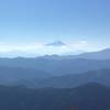
Weather permitting, there are some great views of Mt. Fuji along the way.
During the climb, you'll pass a couple of monuments, a group of Buddha statues and a rock climbing area.
Near the top of the mountain, a few trails come together so you'll want to pay attention to the signs, a map, or the
Trail Run Project mobile app to make sure you take the right trail to the summit.
On the way down to Lake Kawaguchi from the summit, there are a couple of trails that branch off. One of the trails will take you to Chureito Pagoda, a famous pagoda with a view of Mt. Fuji.
Just before reaching the end, you'll run into the top of the Mt. Fuji Panoramic Ropeway. During the right time of year, the trail down from the ropeway station is lined with hydrangea bushes.
Flora & Fauna
There are bear and deer in the area.
Shared By:
Jesse Eriksen

 Continue with onX Maps
 Continue with Facebook


 Particularly Special Place


 Difficult


0 Comments