Dogs Leashed

Features
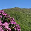
Birding · Commonly Backpacked · Fall Colors · River/Creek · Views · Waterfall · Wildflowers · Wildlife
Description
The trail starts at campsite 11 along FS 126 Bald river road. Immediately cross Henderson Branch to start the trail. Recent flooding has washed out this small portion and water continuously flows down the trail.
Past this is a typical lower elevation, easy going road bed. Horses are allowed on this trail. There is a large campsite shortly after the only ford of Bald River. Upper Bald river falls is found around 2.5 miles. Just ahead of the falls is the junction where the
BMT: Segment 16c-16d (Sledrunner Gap to Tellico River) makes its path.
The left fork crosses over what is known as Brookshire Creek Falls and winds its way toward Tellico River, but you'll continue to the right. This section sees the trail pick up elevation more quickly. Interestingly, in places it is not blazed with the white diamond indicative of the BMT but rather with the white rectangle markings of the AT. Continue onward with a few crossings of Brookshire creek.
Around 6 miles is the signed junction where the BMT parts ways with Brookshire Creek Trail. A left takes you on a less traversed portion of the trail, leading to a grassy patch on Beaverdam Bald where a weathered trailhead marker announces the official end of the trail. Following the service road straight ahead will link you to FS 24 Beaverdam Bald Road. A right turn here takes you up to the crest of the bald and the
Beaverdam Bald Connector.
Contacts
Shared By:
Shaun Blom

 Continue with onX Maps
 Continue with Facebook


 Particularly Special Place


 Intermediate/Difficult


0 Comments