
 Continue with onX Maps
 Continue with Facebook


 Particularly Special Place


 Intermediate/Difficult

 Intermediate/Difficult
Land Manager: USFS - Sierra National Forest Office
 Grand Tour of Sequoias in Mariposa Grove
3.3 mi 5.3 km • 1,092' Up 332.7 m Up • 244' Down 74.42 m Down
 Oakhurst, CA
 Swinging Bridge Loop
4.8 mi 7.8 km • 392' Up 119.41 m Up • 393' Down 119.75 m Down
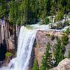
Upper and Lower Rainbow Falls
3.5 mi 5.7 km • 408' Up 124.4 m Up • 408' Down 124.37 m Down
Mammoth…, CA
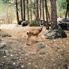
Mono Meadow Sampler
3.6 mi 5.9 km • 449' Up 136.93 m Up • 451' Down 137.35 m Down
 Grand Canyon of the Tuolumne to White Wolf
29.8 mi 47.9 km • 4,681' Up 1426.72 m Up • 5,407' Down 1647.92 m Down
Half Dome
14.5 mi 23.4 km • 4,457' Up 1358.42 m Up • 4,457' Down 1358.36 m Down
Yosemit…, CA


0 Comments