
 Continue with onX Maps
 Continue with Facebook


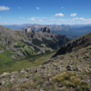
 Particularly Special Place


 Difficult

 Difficult
Land Manager: City of Gunnison
 Lion Gulch Trail Out and Back
6.6 mi 10.7 km • 1,671' Up 509.27 m Up • 1,670' Down 509.09 m Down
Storm Pass Out and Back
17.1 mi 27.5 km • 4,102' Up 1250.42 m Up • 4,102' Down 1250.41 m Down
Crested…, CO
 The Caves Loop Hike
4.5 mi 7.3 km • 970' Up 295.77 m Up • 976' Down 297.62 m Down
Crested Butte Ultra: 50 Mile Course '22
50.0 mi 80.5 km • 8,150' Up 2484.26 m Up • 8,151' Down 2484.32 m Down
 Teocalli Ridge Loop
11.5 mi 18.5 km • 2,131' Up 649.5 m Up • 2,134' Down 650.57 m Down
 Boulder Lake Out-and-Back
7.4 mi 11.9 km • 1,958' Up 596.86 m Up • 1,958' Down 596.65 m Down
St. Elmo, CO


0 Comments