Dogs Leashed

Features
Views
Overview
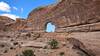
A relatively short Moab classic offering big cliffs and phenomenal views.
Runner Notes
Please stay on the existing trail and do not trample vegetation or fragile biological soil crusts by trying to avoid sandy sections. The sand is never deep and never lasts for more than 20 feet so just consider it a good training exercise and run through it. There are already places where the valley is scarred by 4-5 parallel trails that have developed overtime.
Description
The trail starts with a steep climb up to the mouth of the valley. There are numerous large step-ups with loose rocks, sand, and switchbacks making it difficult to run. After approximately three-quarters of a mile, you reach the top of the climb and enter the valley. The trail from here to the end of the valley is hard-packed dirt with gradual inclines and very few rocks or obstacles, and some short sections of sand.
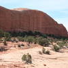
At 1.6 miles, you reach the top of the valley, and the trail starts to descend toward the Colorado River. The scenery changes from tall red cliffs to rolling, yellow sand dune rock formations. Here the trail is more difficult to follow so keep your eyes out for cairns—small piles of stacked rocks that mark the trail. The trail crosses variable terrain including slickrock, loose rock, and doubletrack roads with small sections of sand. The trail ends where it meets the
Moab Rim Trail at mile 3.3. You can retrace your steps to the trailhead or arrange a shuttle and continue down the
Moab Rim Trail to Kane Creek Road.
Contacts
Shared By:
Amy White

 Continue with onX Maps
 Continue with Facebook


 Particularly Special Place


 Intermediate/Difficult

 4.3 (15)


0 Comments